As Maryland braces for a significant winter storm, most of us are doing what we always do: checking the weather on our phones, glancing at the predicted snowfall total, and deciding whether we really need to worry.
But storms like the one approaching right now are exactly when relying on your default phone forecast can mislead you — not because weather apps are useless, but because they oversimplify the very things that matter most in a severe snowstorm. This isn’t just about how many inches fall. It’s about when the snow begins, how quickly roads become dangerous, whether ice mixes in, and how long freezing temperatures stick around afterward.
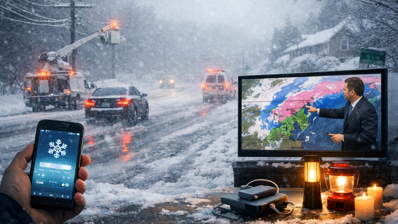
Local meteorologists are warning that travel could become hazardous and that winter storms like this can bring power outages and difficult conditions across the region. And that’s why local news stations still matter.
Snow forecasting doesn’t work in a quick-glance format
A phone forecast is designed for convenience — a number, an icon, and a temperature trend. But snowstorms are complicated. A storm’s track can shift slightly, and that one small change can mean completely different outcomes from one county to the next. Even within the same city, some neighborhoods can get hit harder depending on timing, temperature, and wind.
Local stations provide something your phone often can’t: context. They explain what’s likely, what’s uncertain, and what residents should actually prepare for based on the most up-to-date information.
Why phone forecasts fall short for snow
WBAL-TV meteorologist Tony Pann explains the problem plainly: phone weather forecasts often aren’t the most accurate, especially for snow.
Many phone weather forecasts are powered by automated systems that translate numerical weather model output into simple, easy-to-read predictions. These systems rely on pattern recognition applied to large datasets generated by government and international weather agencies, including satellite observations, radar data, weather balloons, and surface sensors.
While this technology is powerful, it often presents a single blended forecast without showing uncertainty, timing nuances, or competing model scenarios. Snowstorms are particularly challenging because small differences in temperature, storm track, or timing can dramatically change outcomes, and model error margins can grow quickly in winter conditions.
Local meteorologists don’t just read one output — they evaluate multiple models, understand where those models tend to struggle, and apply local knowledge to interpret what the data actually means for specific neighborhoods and travel conditions. That human judgment becomes especially important when forecasts are still evolving and when the consequences of being wrong are higher.
That means your phone might display a number that looks confident, even when the overall forecast is still evolving. Local meteorologists, on the other hand, compare multiple models, track storm trends, and apply years of experience to interpret what those models mean for your specific area.
This is where the human touch matters most. Snowstorms require judgment, not just raw data.
This storm brings dangerous cold that shouldn’t be ignored
This weather event isn’t just a snow headline — it’s a cold-weather safety concern. WBAL reports that temperatures may drop into the single digits Fahrenheit, with wind chills potentially feeling like 0 to -10°F in the Baltimore area, along with a stretch of freezing conditions lasting for days.
That changes everything. Snow and ice won’t melt quickly. Roads can refreeze overnight. Sidewalks stay slick. And if power goes out — even briefly — it becomes a serious issue, especially for older adults and families with young children.
A phone forecast might show “snow” and “cold,” but local stations explain what that combination does to a community.
How to prepare before the storm arrives
Local stations don’t just predict weather — they help people respond to it. WBAL’s coverage highlights real-world concerns like hazardous travel and potential power outages, which is why preparing early makes such a difference.
Consider taking these steps now:
- Charge phones, laptops, and portable battery packs in case of outages
- Get flashlights ready and keep extras where you can find them quickly
- Know where your home’s water shut-off valve is in case pipes freeze
In prolonged outages, internet connectivity can become another challenge. In addition to traditional cable and cellular service, some households and organizations now use satellite internet systems such as Starlink, which operate independently of local ground infrastructure. When available, satellite-based connections can help maintain access to weather updates, emergency information, and communication tools during widespread disruptions. While not a replacement for local alert systems or broadcast media, satellite internet can serve as an additional layer of resilience when other networks are affected.
Updates matter more than the initial forecast
Winter forecasts often shift — sometimes dramatically — right up until the storm arrives. A phone forecast might update quietly in the background without explaining what changed or why.
Local meteorologists will tell you if the storm track is moving north or south, whether the heaviest snow is shifting into a new area, if ice is becoming a bigger threat, and critically, when conditions will become dangerous and when they may improve. During a serious storm, that’s not just helpful information — it’s potentially life-saving.
Our recommendation: Multiple sources, better safety
At the Carroll Technology and Innovation Council, we’re committed to helping our community stay connected and informed, especially during severe weather events. While we appreciate the convenience of technology like weather apps, we also recognize their limitations when it matters most.
Your phone forecast is useful for ordinary winter days, but as this snowstorm approaches, it’s not enough to rely on a single app and a single number. We encourage all Carroll County residents to use multiple information sources to stay safe:
- Local TV stations: WBAL-TV and other Baltimore-area stations provide expert analysis and frequent updates
- Social media: Follow local meteorologists directly for real-time insights and forecast changes
- Weather radio: NOAA Weather Radio provides alerts even if power or internet goes out
- Community networks: Check in with neighbors, especially those who may have limited access to technology
In a storm like this, being “a little off” doesn’t just mean inconvenience. It can mean the difference between being ready and being caught off guard.
Technology is a powerful tool, but during severe weather, the human expertise behind local forecasting becomes essential. We want every member of our community to have access to the most accurate, timely information possible — because when conditions are changing by the hour, that local knowledge can keep you and your family safe.
Learn more about how we support community preparedness and connectivity at the Carroll Technology and Innovation Council – come to a workshop when the snow clears!
Key takeaways for winter storm forecasting
- Phone weather apps often present a single blended forecast that hides uncertainty, especially during snowstorms.
- Local meteorologists evaluate multiple models and apply regional experience to explain real-world impacts.
- During severe winter weather, using multiple information sources can improve safety and preparedness.